Historic England Repeat Objections to Southern Link Road

Historic England (HE, formerly English Heritage) for the second time, are recommending refusal or deferral of the Council’s application to build a link road in South Hereford, across the open countryside of Grafton and Merryhill. Their Principal Inspector of Ancient Monuments writes that Historic England is not sure that the relative weight afforded to the historic environment is robust enough to allow demonstrable compliance with National Planning Policy Framework (NPPF) Section 12 (Conserving And Enhancing The Historic Environment). Continue reading ...

Posted in Transport | Tagged , | Leave a comment

Southern Link Road & Hereford’s Ecology Network

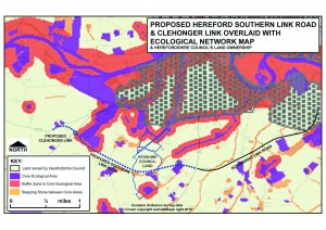
SLR_WITH_ECOLOGICAL_NETWORK_MAP_OVERLAY_V2
This map shows the proposed Hereford Southern Link Road and Clehonger Link overlaid with the “Ecological Network” map produce in 2013 by Herefordshire Council.It also shows the Herefordshire Council Land ownership.
The Ecological Network map is part of the Core Strategy Local Plan which  states (para 5.3.16) “Development within and adjacent to these core areas and associated
buffer zones will need to be sympathetically designed to ensure there are
no adverse impacts upon them.” Note the “NO ADVERSE IMPACTS”. The map is somewhat limited as it does not necessarily include all important sites and linkages. For example, the footpath between Grafton Wood and the A49 should qualify as a wildlife corridor, as it is clearly an ancient track with old hedges on both sides, and a clear ancient boundary bank on one side. Continue reading ...

Posted in Transport | Tagged , , , | Leave a comment

“Unsound” Local Plan Approved after Pressure from Westminster?

Here for Hereford has been engaged throughout the development of the Herefordshire Local Plan to try and ensure that the growth planned for the County, in particular for Hereford and its rural hinterland, is sustainable and enhances the local economy and environment, and improves health and well being for its residents. Continue reading ...

Posted in Local Development Framework | Tagged , | Leave a comment

“Extraordinary” Meeting to Adopt Local Plan 2011-2031

After 8 years in the planning what is the actual Local Plan for Herefordshire for 2011 to 2031? Here for Hereford has been trying to find out for over a week now, what the final Local Plan documents for adoption at the Extraordinary Council meeting on Friday 16th Oct 2015 actually are. We have had no clear response and on Friday 16th Oct we found out why – no one really knows what documents are to be sent to the Secretary of State as the Local Plan for Herefordshire 2011-31. Continue reading ...

Posted in Local Development Framework | Tagged , , | Leave a comment

How Traffic Increases with the Southern Link Road, Hereford

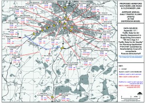
SLR_TRAFFIC_FLOWS_MAPPED_V2
This map shows the AVERAGE ANNUAL DAILY TRAFFIC FLOWS (AADTs) from a 2012 baseline and with the construction of the Southern Link Road in both 2017 and then 2032. All data has come from Herefordshire Council’s consultants Parsons Brinkerhoff as part of the planning application for construction of this new £27million road.
Modelling and forecasting traffic is very complex so we are trying to keep it simple.
The modelling shows that when the Southern Link Road is opened in 2017:
a. A465 Belmont Road traffic on the would decrease by 13%  (on section B below the Asda gyratory).
b. A49 Ross Road Traffic  would increase by 15% ( on the section L below the Asda gyratory).
c. Traffic on A49 Greyfriars Bridge would remain unchanged at 45,000 per day. Continue reading ...

Posted in Transport | Leave a comment

High Grade Agricultural Land in the Southern Link Road Corridor

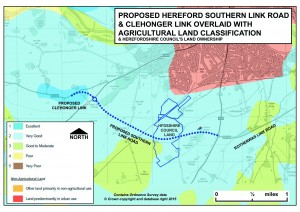
SLR_WITH_AGRIC_LAND_OVERLAY_V2
This map is taken from the Herefordshire Land Classification Map and shows the land in the corridor of the Southern Link Road, graded from 1, the highest grade, down to grade 5, the poorest soils. The best and most versatile land is defined by the National Planning Policy Framework (NPPF) as Grades 1, 2 and 3a. These top grades of land are the most flexible, productive and efficient in response to inputs and can best deliver food and non food crops for future generations. Soil is a non-renewable resource with its preservation essential for food security and our sustainable future. Soils host a quarter of the planets’ total biodiversity, as well as acting as a store and water filter, improving our  resilience to floods and droughts. Continue reading ...

Posted in Agriculture, Transport | Leave a comment

Housing and the Southern Link Road

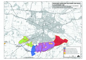
SLR_WITH_2012_SHLAA_OVERLAY_V2
THIS MAP SHOWS: The Southern Link Road and Potential Housing Development sites from the  Strategic Housing Land Availability Assessment (SHLAA).
THE MARCHES LEP AND HEREFORDSHIRE COUNCIL STATE THAT THE SOUTHERN LINK ROAD WILL ‘UNLOCK LAND FOR HOUSING’.  THIS CAN ONLY BE TRUE IF THERE IS GOING TO BE SIGNIFICANT HOUSING DEVELOPMENT NEAR THE SOUTHERN LINK ROAD WHICH HAS NOT YET BEEN REVEALED.
We have provided this information to show:-
a. The Southern Link Road (and Rotherwas Link/Access Road) act as “Distributor” Roads to open up land for significant housing around Hereford.
b. Using an average housing density of 35 dwellings per Hectare (the Core Strategy
Southern Urban Expansion density), and applying that to the SHLAA land
areas, the total potential for houses on the SHLAA sites would be 12,705.
c. The Southern Link Road traverse the small holding land in Herefordshire Council’s ownership which could deliver a further 2,310 homes. Total housing potential is 15,015.
d. The number of houses assigned to the Southern Urban Expansion in the
Core Strategy is 1,000 MINIMUM. So the 14,015 house building potential is currently not explicit in any plan. However, the total number of houses to be delivered for Hereford is a minimum of 6,500 to 2031. With Herefordshire Council needing the new Homes Bonus to fund the Southern Link Road expect delivery of new house building within the Southern Link Road area.
d. Traffic from these houses will still need to access Hereford for work, schools, hospitals or shopping so do not be fooled by claims that a Relief Road will enable that. 85% of traffic in Hereford is “internal” i.e. starting and finishing journeys within the City. Any so-called ‘Relief Road’ will not go into Hereford.
e. The “constraints” which could prevent delivery on these SHLAA sites are likely to disappear under the Core Strategy  and the National Planning Policy Framework rules.
f. There is currently a 2015 “call for sites” underway by
Herefordshire Council with developers and land owners to update the 2012 SHLAA. When this becomes publicly available we will publish an updated map. Continue reading ...

Posted in Transport | Leave a comment

Government Faces Legal Challenge for Failing to Protect the Rivers Wye & Lugg

The Angling Trust; WWF-UK and Fish Legal have been granted permission by the High Court to seek a judicial review of the government’s failure to protect some of England’s most precious rivers from agricultural and other pollution. The case includes the River Wye and its tributary the River Lugg, which are designated a European Special Area of Conservation (SAC) due to the rare species such as various types of Lamphrey, the Atlantic salmon and the native white clawed crayfish, that can be found in its waters and which use the River Wye catchment area as a breeding ground. In 2011 the River Wye was declared the “Nation’s Favourite River” and plays an important role not just in providing fresh drinking water for local communities, including Hereford City residents, but also in generating employment and income for the County. Continue reading ...

Posted in Agriculture, Local Development Framework | Leave a comment

The Southern Link Road Planning Application (Ref P151314/F)

Herefordshire Council have made a planning application for the “Southern Link Road” to link the A49 and A465 south of Hereford and to then extend this road to link with the Clehonger road (B4349). (Full application page here ). The Council believe that this single carriageway road is the best way to tackle congestion in the South Wye area. The road has no footpath or cycleway along its length as it is purely designed for cars and lorries. A 7 metre (approx. 24 foot) high road bridge will be built to take cars and lorries over the railway line to South Wales. Continue reading ...

Posted in Transport | Leave a comment